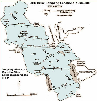
Brine Chemistry Sample Sites
Great Salt Lake Brine Chemistry Databases & Reports 1966-2006, J Wallace Gwynn: Utah Geological Survey Open-File Report OFR-485, 2007, 22 pages, misc. reports, Excel files.
DETAILS OF GREAT SALT LAKE BRINE DATABASES |
The following Excel® files are included in the Utah Geological Survey's Great Salt Lake brine database: AS2 & FB2.xls; LVG4, ECN & RD2.xls; SOUTH OLD.xls; NORTH OLD.xls; BRBS.xls; GSLB.xls; MISC.xls; DEN1-4S.xls; DEN 13A.xls; DEN 1-4N.xls; DENRT2.xls; DENRT3.xls; and DENRT4.xls. The following paragraphs give details of the contents of the individual files.
File AS2 & FB2.xls contains 1778 south-arm chemical analyses from the AS2 and FB2 sites (see figure 1) for the period 1966 to 2006, and file LVG4, ECN and RD2.xls contains 1243 north-arm chemical analyses from the LVG4, ECN and RD2 sites (see figure 1) for the period 1966 to 2006. Both of these files contain location (latitude, longitude, UTM-north, and UTM-east); date of sampling; depth of the sample from the surface in feet; laboratory density; concentration values for Na, Mg, K, Ca, Cl, SO4, and TDS all in terms of grams per liter; and Br, Li, and B in terms of parts per million. The above values are followed by WT%-TDS (weight percent of dissolved solids), LK-ELEV (lake elevation), SAMP-ELEV (sample elevation), and DWP_NA (dry-weight percent of the various major ions).
Files SOUTH OLD.xls and NORTH OLD.xls represent south- and north-arm data, respectively. The SOUTH OLD.xls file contains data from the following sampling sites: AC1-4, AS1-AS5, FB1-FB4, IS1, IS2, NLN, RT1 and RT2, and SS, and contains 5478 records. The NORTH OLD.xls file contains data from the following sampling sites: ECN, LVG1-LVG5, NML, RD1-RD4, and contains 2419 records. Both files contain location (latitude and longitude); date sampled; depth of sample from the surface; lake elevation and sample depth; F.Den (field density); L.Den (lab density); concentration values for Na, Mg, K, Ca, Cl, SO4, and TDS in terms of grams per liter; and Br, Li, and B in terms of parts per million. The above values are followed by WT%-TDS (weight percent of dissolved solids).
Files BRBS.xls, GSLB.xls, and MISC.xls present chemistry data from the Bear River Bridge (south), Great Salt Lake bridge, and miscellaneous sites (ABN, HI, LCI, LVH, MI, NLI, and SE locations). These files contain location (latitude, longitude, UTM-north, and UTM-east); date of sampling; depth of sample from the surface; field and lab density; brine temperature; the ions Na, K, Mg, Ca, Cl, SO4, and TDS in terms of grams per liter; Li, Br, and B in terms of parts per million; and weight percent total dissolved solids.
Files DEN 1S-4S.xls, DEN 1A-3A.xls, DEN 1N-4N.xls, DEN RT2.xls, DEN RT3.xls and DEN RT4.xls contain the following information: site, location (latitude, longitude, UTM-north, and UTM-east), date of sample, depth from surface, and laboratory density, lake elevation, and sample elevation. These files contain no chemical data.